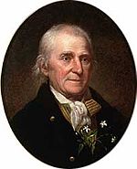
In Search of William Bartram
In Guide to William Bartram’s Travels – Following the trail of America’s First Great Naturalist, we are treated to a detailed retracing of Bartram’s four-year journey through the American South. Alas, just as Bartram nears Chatham County on his way home to Philadelphia, the trail goes cold, and we get only a general idea of the route. Can we add some precision?
Here is William Bartram’s Wikipedia
entry:
In 1773, he embarked upon a four-year
journey through eight southern colonies. Bartram made many drawings and took
notes on the native flora and fauna, and the native American Indians. In 1774,
he explored the St. Johns River, where he had memorable encounters with
aggressive alligators which he recorded in one of his journals, Travels
through North and South Carolina, Georgia, East and West Florida, and also
visited a principal Seminole village at Cuscowilla, where his arrival was
celebrated with a great feast. He met Ahaya the Cowkeeper, chief of the Alachua
band of the Seminole tribe. When Bartram explained to the Cowkeeper that he was
interested in studying the local plants and animals, the chief was amused and
began calling him Puc-puggee (the flower hunter). Bartram continued his
explorations of the Alachua Savannah, or what is today Payne's Prairie."
Now to our project:
In 1776 Bartram made the return journey
to Philadelphia by way of the Cape Fear River. He writes of travelling up the Haw River about 60 miles from
Fayetteville, crossing the Haw and the Roanoke, and reaching the Meherren River in Virginia late in the
year.
Speaking of present-day Fayetteville,
then known as Cambelton, Bartram writes:
When
I was here about twenty years ago, this town was marking out its bounds, and
there were then about twenty habitations, and now there are above a thousand
houses, many wealthy merchants, and respectable public buildings, a vast resort
of inhabitants and travellers, and continual brisk commerce by waggons, from
the back settlements, with large trading boats, to and from Wilmington, the
seaport and flourishing trading town on the Clarendon, about forty miles above
the capes, which is about one hundred miles below this town. The Clarendon or
Cape Fear river has its source in the Cherokee mountains, where its numerous
confederate streams unite, after leaving the first ridges of the mountains, it
assumes the name of Haw river, and coursing the hilly fertile country, above
one hundred and fifty miles, receives through its West banks the West branch,
called Deep river, and after this union, takes the name of the North-West of
Cape Fear, from whence down to Cambelton, about eighty miles, it is navigable
for perriauguas of considerable burthen.
OBSERVED
near Cambelton a very curious scandent Fern (Pteris scandens) rambling over low
bushes, in humid situations, the lower larger fronds were digitated, or rather
radiated, but towards the tops or extremities of the branches they became
trifid, hastated, and lastly lanciolate; it is a delicate plant, of a yellowish
lively green, and would be an ornament in a garden.
SAT
off again to (he means from) Cambelton, continuing yet up the North West about
sixty miles (63 miles to Cane Creek Quaker Meeting), crossed over this branch
(at Saxapahaw?), and soon after crossed the Roanoke, and then rested a few days
at Mr. Lucas', a worthy old gentleman, a planter on Meherren river. Observed
strolling over his fences and stables, a very singular and useful species of
the Gourd (Cucurbita laginaria) their necks or handles are above two feet in
length, and not above an inch in diameter; their bellies round, which would
contain about a pint; they make excellent ladles, funnels, &c. At a little
distance from Mr. Lucas', at the head of a swamp near the high road, I observed
a very curious species of Prinos, which grows seven or eight feet high, the
leaves broad, lanciolate, sharply serrated, nervous, and of a deep green
colour; but its striking beauty consists in profuse clusters of fruit,
collected about the cases or origin of the last spring's shoots; these berries
are nearly round, about the size of middling grapes, of a fine clear scarlet
colour, covered or invested with an incarnate mist or nebulae.
BEING
now arrived on the South border of Virginia, and the hoary frigid season far
advanced, I shall pass as speedily as possible from hence to Pennsylvania, my
native country; since those cultivated regions of Virginia and Maryland,
through which I design to travel, have been over and over explored, and
described by very able men in every branch of natural history.
From Fayetteville to the Meherren the path looks like the
dogleg in this map:

Can we be more accurate? We can overlay A compleat map of North-Carolina from an
actual survey, published in London in 1770
like so:

With a little tweaking and
adding a few reference points it’s possible to get a pretty accurate match. As shown on the 1770 map, the Haw is a
mile wide at Saxapahaw, but otherwise the map is a testament to 18th
century cartography.
We are particularly interested in
the Pittsboro to Hillsborough route.
On this map the red line traces the roads shown on the 1770 map and the
blue line is a close approximation along modern roads:

What was Bartram doing here? He was a Quaker, and the Snow Camp area
was settled by Quakers as early as 1751.
The presumption is that Bartram visited and stayed with members of the
Cane Creek meeting on his way through.
The road on the 1770 map passes
somewhat west of Pittsboro (founded 1785) and there is no good match of present
routes. The 1770 route also passes
within a few yards of Silk Hope crossroads, matches precisely with Snow Camp, the
Quaker Meeting House at Cane Creek and is a good fit with a route on into Hillsborough. It looks like the crossing of the Haw
took place below Saxahapaw, although there is another crossing further north at
Armstrong’s Mill (Swepsonville).
That is a somewhat longer route to Hillsborough.
John Woody, an early Quaker
settler, operated a ferry just below Saxapahaw:
“In 1759 John received a grant from the State of N.C. for 374
acres on the south side of Haw River, just above a confluence of the Marys
Creek. The south end of a ford was on their land, and John built and operated a
ferry there. Present-day location of this land grant is about 20 miles
southwest of Hillsboro, now known as Saxapahaw.”
This blue route is a lovely drive,
through farm country with rolling hills, extensive vistas, wonderful trees and
interesting stops. Pittsboro didn’t become a town until 1785, so Bartram
probably didn’t dally here.
Here are directions with some annotations:
From: Pittsboro, NC
1. Head toward US-64 BUS
2. Exit the traffic circle onto
US-64 BUS W 0.5
mi
3. Turn right onto N Carolina 87 N 3.9
mi
4. Turn left onto Silk Hope Gum
Spring Rd 8.1
mi
Silk
Hope Winery
5.
Continue onto Silk Hope Liberty Rd 4.1
mi
Silk
Hope Farm Heritage Park
6. Turn right onto Siler City Snow
Camp Rd 2.5
mi
7. Continue onto Snow Camp Rd 3.5
mi
8. Turn right onto E Greensboro
Chapel Hill Rd 7.2
mi
Lindley
Mill Rd
1
mile south to Lindley Mill and 1781 Battlefield
Cane
Creek Meeting
9. Turn left onto N Carolina 87 N 2.5
mi
Benjamin
Vineyards nearby
10. Turn right onto Church Rd 1.1
mi
11. Slight right onto
Saxapahaw-Bethlehem Church Rd 3.4
mi
12. Continue onto Saxapahaw Rd 0.4
mi
Lots
to do in Saxapahaw
13. Continue onto Mebane Oaks Rd 1.1
mi
14. Turn right onto Bradshaw
Quarry Rd 5.1
mi
15. Turn left onto Orange Grove Rd 7.0
mi
16. Turn left onto S Churton St 0.7
mi
17. Turn left onto W King St 92
ft
Lots
to do in Hillsborough
Grave
of William Hooper, who signed the Declaration of Independence
Hillsborough, NC
Link to a Google map at http://g.co/maps/4uqsp
Got more info? Let me know wcreedh@gmail.com